Project Goal & Description:
In 2020 and 2021, the City of Airway Heights, in coordination with the City of Spokane (https://my.spokanecity.org/) and S3R3 (https://www.s3r3solutions.com/), a City of Spokane and County Public Development Authority, worked to plan an alternative corridor for local mobility and property access north of U.S. Highway 2. This alternative corridor had been identified for several years in community plans. Named West Plains Connection, the resulting planning and design study identified a multimodal route extending along the alignments of 6th Avenue and 10th Avenue within Airway Heights and 12th Avenue within Spokane to serve both local residents and businesses and local commuters. In addition, the study emphasized the need for travel choices, pedestrian and bicycle facilities, and improved transit accessibility to help reduce reliance on personal automobiles. Through a community engagement process, virtual survey, and subsequent Airway Heights City Council meetings, the majority of citizens from Airway Heights identified the preference for extending a landscaped boulevard street (a scenic median complimenting roadside areas) with a shared-use path, improved pedestrian/bicycle lighting, transit facilities, and traffic calming measures (narrow lanes) to establish a complete street route to benefit all traveler movements and safety within the community. In summary, the community requested that the project achieve the following outcomes:
- Reduce vehicle speeding along the corridor
- Provide safe pedestrian crossings at key intersections
- Provide a safe walking zone for children walking to and from school
- Provide an alternate local trip arterial to reduce traffic congestion on US2
- Provide for a landscaped boulevard design, including stormwater storage and infiltration, water conservation through drought tolerant plants and use of reclaimed water irrigation, and lower maintenance
- Provide for multimodal uses, including a separated bicycle lane outside the vehicle lane
- Provide for increased transit services
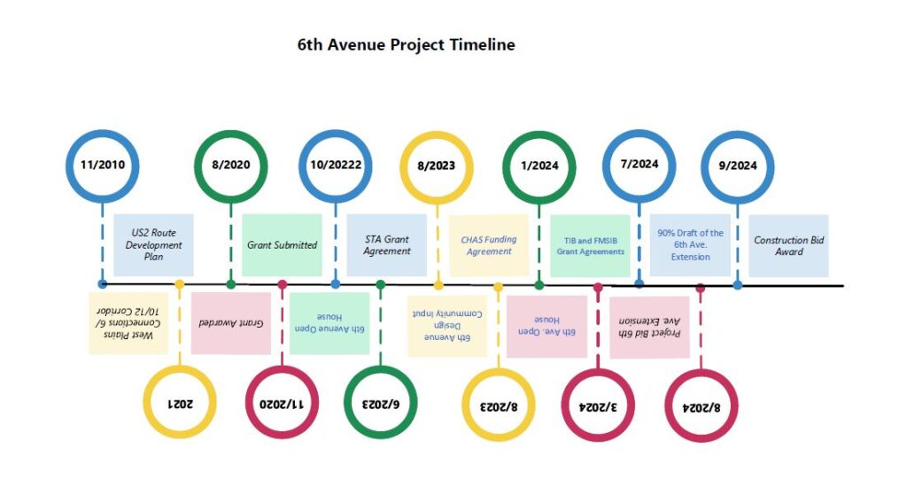
Since study finalization, leaders with Airway Heights have been active in developing partnerships with the Kalispel Tribe of Indians, the Spokane Tribe of Indians, and Spokane Transit Authority, and securing grants to extend City sections of the corridor; approximately $10 million in four years. The City has recently enjoyed the completion of the 10th Avenue extension project, Garfield Road to Hayford Road with a Hayford Road traffic and pedestrian signal; the construction of the Craig Road multiuse pathway from U.S. Highway 2 to 6th Avenue; and they are now witnessing progress on the 6th Avenue extension project, Craig Road to Russell Street.
The great positives of these projects are noted as the high use of completed corridor sections, in particular, the use of the multiuse pathways extending along 10th Avenue and Craig Road, while citizens appreciate the context-sensitive designs of trees, shrubs, and grassy areas. However, the City has received and understands recent frustration with the advancement of the 6th Avenue extension project. Of particular concern: access from driveways and temporary blockages, at times, due to transit, paratransit, and delivery-truck activities.
To relieve driveway access concerns, the City inventoried existing driveways and access based on building permit data, driving surveys, and aerial photography prior to the project starting.
- Driveways were retained along the corridor in the existing size they have been built, and for areas where there were no driveways (dirt or gravel access), designs were included to facilitate access to each parcel with a driveway.
- In addition, a letter was sent to all property owners along 6th Avenue in early 2024 of the roadway under design, construction timelines, and the opportunity to communicate driveway needs. Several property owners contacted the City and worked with the City’s design consultant, Ardurra, to modify driveway designs or add driveways, including for recreational vehicles. This letter was one of three letters in 2024 sent to property owners along 6th Avenue, which includes information about the project, contact information for the City project team and Ardurra, and requests for contact if property owners needed driveway modifications, water, or sewer connections.
- Finally, a fourth letter was provided regarding obstructions in the existing right of way that needed to be moved for the construction.
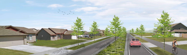
Several community engagement inputs led to the boulevard design of the corridor with narrowed lanes.
- First, citizens identified the desire to have a boulevard-style roadway through the engagement process, as shown below.
- Also, residents who use 6th Avenue indicated concern for safety over existing high vehicle speeds along the road. Roads are most effective when designed to address problems of speed and safety up front rather than attempting to address them after the fact with stop signs or law enforcement. The project was designed with speed and safety as factors to be addressed; elements included in the design called on traffic calming to address them: boulevard design with landscaping, narrowing lanes from the standard 12 feet to 11 feet, and the application of two compact roundabouts. These features will result in slower-moving vehicles meeting the current 25-mile-per-hour speed limit.
- The design also facilitates through-vehicle travel. Roundabouts allow all directions to continue to travel, unlike stop signs. 6th Avenue is currently a Major Collector, an arterial intended to move traffic through local access streets and feed vehicles from neighborhoods and other arterials through the area.
There may be temporary blocks of through mobility caused by service vehicles like garbage service and STA busses. These pauses by service vehicles are designed to be short intervals with minimum delay and are monitored by these entities to ensure timely services. Recent reports have included vehicles parking in the street, such as large delivery trucks, which are not intended nor permitted to park on the road. The City teams are reaching out when notified of these instances to the companies, so they are aware of the impact caused on parking. Additionally, no parking signs are being installed along the road. City employees are also communicating with drivers who park on the street and the Airway Heights Police Department, as available, will be monitoring the road.
With that said, the City has been and continues to be interested in community input and their desires for street projects such as the 6th Avenue Multimodal Extension project. We desire and encourage continued input on other projects under design, per the contact information below. We will continue to work for the community on this and other future roadway projects.
Where can I find more information?
If you have a specific question, you may contact the Project Manager, ReBecca Fouts, at [email protected] or City Planning Director, Heather Trautman, at [email protected].