Roadway Projects
US 2 Highway Project
Project Overview
US Highway 2 is the backbone of Airway Heights. It serves as the City’s main street, a regional transportation corridor, and the heart of the central business district. Over time, US-2 has taken on more roles than it was originally designed for and is responsible for carrying high volumes of traffic while also serving people who live, work, shop, and travel through the community.
Improving the appearance, safety, and function of US-2 has been a long-standing community priority. As Airway Heights has grown, the corridor has experienced increased traffic, changing land uses, and greater demand from pedestrians, bicyclists, transit users, and local businesses. While US-2 is essential for regional mobility, its current configuration reflects an earlier era focused primarily on vehicle movement, creating challenges for safety, accessibility, and community identity.
Why This Project Is Needed
Community members and City leaders have consistently identified key issues along the corridor, including safety concerns at intersections and crossings, gaps in pedestrian and bicycle facilities, limited comfort for people walking or using transit, and the need for a more cohesive and welcoming streetscape. Balancing the corridor’s regional role with its function as Airway Heights’ main street has been a recurring theme.
Data collected over multiple years shows that portions of US-2 in Airway Heights are identified on the region’s High Injury Network, meaning serious injury and fatal crashes are more likely to occur along the corridor. This project aligns with WSDOT’s Target Zero initiative, which focuses on reducing traffic deaths and serious injuries through safer speeds and roadway design improvements rather than enforcement alone.
The US-2 Multimodal Project addresses these challenges by looking beyond vehicle capacity alone. The goal is to create a corridor that safely and efficiently serves all users while supporting local businesses, improving access, and reflecting the City’s long-term vision.
The project also reflects a Main Street approach, intended to retain existing businesses and encourage local traffic to stop, shop, and spend time along the corridor rather than simply pass through it.
Building on Years of Planning
The US-2 Multimodal Project builds on more than a decade of coordinated planning, technical analysis, and public input focused on improving safety, mobility, and community character along Airway Heights’ main street. Rather than a stand-alone effort, the project advances a long-established vision for US-2 as both a critical regional highway and a place that supports local businesses, neighborhoods, and daily life.
A cornerstone of this work is the US-2 Corridor Plan, adopted by the City in 2017. That plan established a long-term vision for transforming US-2 into a safer, more attractive, and more multimodal corridor while continuing to serve its essential regional transportation role. It emphasized improved pedestrian and bicycle connectivity, safer intersections, access management, and streetscape elements that reflect Airway Heights’ identity, while recognizing that implementation would occur incrementally over time.
Because US-2 is a state highway, the Washington State Department of Transportation (WSDOT) has been a key partner throughout the planning process. Regional transportation studies identified US-2 as one of the most heavily traveled corridors in the West Plains and highlighted the need to balance mobility, access, and safety as traffic volumes increased. Through collaboration with the City, WSDOT helped evaluate operational challenges, collision trends, and design strategies that could improve safety while meeting state and federal highway requirements. These efforts laid the groundwork for translating long-range planning concepts into implementable corridor improvements.
Planning for US-2 has also consistently recognized the importance of Fairchild Air Force Base, which relies on the corridor as its primary connection to Spokane and the surrounding region. The highway carries significant daily traffic associated with base operations, employees, and freight, making reliability and safety critical at both the local and regional level. Coordination with Fairchild during earlier planning helped ensure that corridor improvements support military access needs while also enhancing safety and functionality for the broader community.
Together, these efforts established a clear foundation for the US-2 Multimodal Project. The current design represents the continuation of years of planning and partnership by advancing improvements that respond to community priorities, align with regional transportation goals, and move Airway Heights closer to its long-term vision for the corridor.
What the Project Includes
The US-2 Multimodal Project considers a range of improvements along the corridor, including:
- Closing gaps in sidewalks and pedestrian connections
- Improving crossings with high-visibility markings and rapid flashing beacons
- Improving intersection safety
- Enhancing bicycle accommodations by providing multi-use pathways
- Supporting transit access and operations
- Incorporating streetscape elements that reinforce community identity
- Maintaining access to businesses while supporting regional travel
Together, these improvements aim to make US-2 safer, more comfortable, and more functional for everyone who uses it.
Where the Project Is Today
The project is currently in the 90% design phase, meaning the design is nearing completion and reflects technical analysis, coordination with partner agencies, and extensive community input. At this stage, the overall layout and design approach are well established, with remaining work focused on refining details and preparing for final design and future implementation.
Reaching the 90% design milestone represents a major step forward and reflects the City’s long-term commitment to improving the US-2 corridor.
What to Expect
As the project nears completion of the 90% design phase, the City of Airway Heights will continue to share information and gather feedback from the community. Outreach at this stage focuses on explaining the project’s purpose, sharing the near-final design, and highlighting how public input has influenced the outcome.
To streamline engagement and create meaningful connections, public outreach for the US-2 Multimodal Project is being coordinated with outreach for the City’s Comprehensive Plan Update. This combined approach allows residents and businesses to engage in broader conversations about the City’s future while learning about specific transportation improvements.
Upcoming engagement opportunities include:
- An online open house with project information, graphics, and a comment option
- In-person engagement activities coordinated with Comprehensive Plan outreach
- Targeted meetings with business owners and community stakeholders
- Continued updates to the project website, with materials available in multiple languages
Following completion of the 90% design phase and public outreach, the project will move toward final design and future implementation steps. The City appreciates the community’s continued interest and involvement as work progresses to improve US-2 for everyone in Airway Heights.
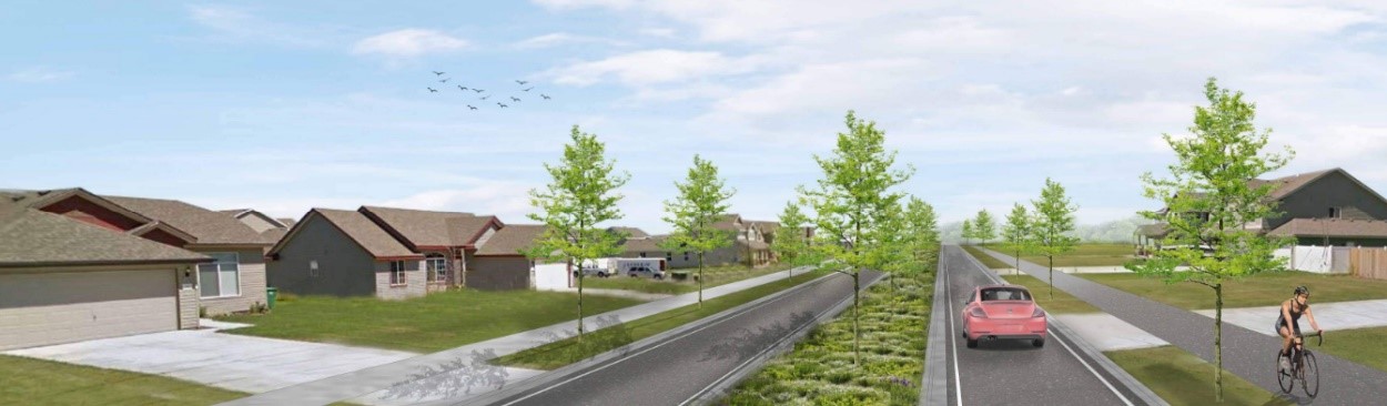
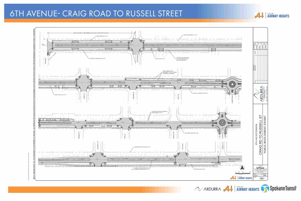
6th Avenue Extension - Craig Road to Russell Street
Project Overview
The 6th Avenue segment between Craig Road and South Ketchum Drive (600-feet) is being designed as a boulevard, filling in the missing segment of 6th Avenue. From South Ketchum Drive to Russell Street, 6th Avenue will be reconstructed as a boulevard with roundabouts at Lundstrom and Lawson, infill sidewalk on the north side of 6th Avenue, and an 8-10 foot shared-use path on the south side. This design with applicable elements including ADA ramps and drainage swales will require additional City right of way acquisitions.
What to Expect
This project will begin construction in fall of 2024, have a winter shutdown, and pick up in the spring of 2025. Another City utility project will be constructed along 6th this fall concurrently with our project.
Project Goal
The goal of this project is to improve the overall transportation system, and multimodal usability and safety of 6th Avenue between Craig Road and Russell Street. The project includes extending 6th Avenue to Craig Road, sidewalks to eliminate gaps on the north side, a shared-use path on the south side, median treatments to create a boulevard, and transit stops along the route.
90% Draft of the 6th Ave. Extension Project Design Now Available:
Where can I find more information or ask questions?
Contact the Project Manager, ReBecca Fouts, at [email protected] or City Planning Director, Heather Trautman, at [email protected].